Part 7 - Development codes
- Preliminary
- Development that cannot be made assessable in accordance with Schedule 6 of the Planning Regulation 2017
- Use codes
- Other development codes
7.1 Preliminary
- Development codes are codes for assessment where identified as an applicable code in Part 5.
- Use codes and other development codes are specific to each planning scheme area.
- The following are the codes and requirements under the Regulation for development in the planning scheme:
- Community residence code requirements applying to development that may not be made assessable development under the planning scheme
- Cropping (involving forestry for wood production) code applying to development that may not be made assessable development under the planning scheme
- Reconfiguring a lot (subdividing one lot into two lots) and associated operational works code applying to development for which code assessment is required under Schedule 10, part 12 and Schedule 10, part 14, division 2 of the Regulation.
- The following are the use codes for the planning scheme:
- General Development Code.
- Non-Resident Workforce Accommodation Code.
- The following are the other development codes for the planning scheme:
- Operational works code.
- Reconfiguration a lot code
7.2 Development that cannot be made assessable in accordance with Schedule 6 of the Planning Regulation 2017
7.2.1 Community residence requirements
- Development for a community residence that complies with all of the requirements in Table 7.2.1.1 is accepted development.
7.2.1.1 Community residence for accepted development only
| Requirements | |
|---|---|
| 1 | The premises are in a residential zone or rural residential zone. |
| 2 | No more than 7 support workers attend the residence in a 24-hour period. |
| 3 | At least 2 car parks are provided on the premises for use by residents and visitors. |
| 4 | At least 1 of the car parks stated in (3) is suitable for persons with disabilities. |
| 5 | At least 1 car park is provided on the premises for use by support workers. |
Editor’s note—Schedule 6, Part 2, (6) of the Regulation states the development the planning scheme is prohibited from making assessable development for a material change of use for community residence.
7.2.2 Requirements for cropping involving forestry for wood production code for accepted development
The Planning Scheme is in accordance with the relevant requirements from schedule 13, requirements for cropping involving forestry for wood production of the Regulation.
7.2.2.1 Requirements for accepted development that is a material change of use for cropping involving forestry for wood production or operational work for harvesting trees for wood production
| Requirements | |
|---|---|
| Setbacks | |
| 1 | The use or work is at a distance of at least the separation distance stated in Table 7.2.2.2 Separation distances. Refer to Table 7.2.2.2 Separation Distances below. |
| 2 | Seedlings within the separation distance stated in requirement 1 are removed if the seedlings—
|
| 3 | For land with a slope of more than 10% but less than 25% - the development uses only—
|
| 4 | For land with a slope of 25% or more— the development uses only—
|
| Requirements | |
| 5 | The construction, operation or maintenance of a track or road for the development does not adversely affect—
|
| 6 | A track or road for the development—
|
| 7 | Drainage structures for a track or road for the development are regularly maintained. |
| 8 | Drainage water from a track or road for the development is directed away from exposed soils and onto undisturbed ground or other areas with a stable surface. |
| 9 | For development involving a forest for wood production that is less than 40ha— a fire break that is at least 7m wide, measured from the base of the outermost tree in the forest to be harvested, is established and maintained. |
| 10 | For development involving a forest for wood production that is at least 40ha, but less than 100ha—a fire break that is at least 10m wide, measured from the base of the outermost tree in the forest to be harvested, is established and maintained. |
| 11 | For development involving a forest for wood production that is 100ha or more—
|
| 12 | Trees to be harvested in the fuel reduction area are pruned to a minimum height of 5m when the trees reach a height of 10m. |
| 13 | Fire breaks are kept clear of flammable material with a height of more than 1m. |
| 14 | Fire access tracks and roads that are at least 4m wide are established and maintained on the premises. |
| 15 | Each part of the forest for wood production is within 250m of a fire access track or road. |
| 16 | Despite requirement (1), the following works may be carried out within the separation distance mentioned in Table 7.2.2.2 - Separation distances—
|
Table 7.2.2.2- Separation distances
| Column 1 Structure or thing |
Column 2 Separation distance |
|---|---|
| 1. A watercourse shown on the regulated vegetation management map (1:100,000) and classified as stream order 1 to 2 under the Strahler stream order classification system | 5m from the defining bank of the watercourse |
| 2. A watercourse shown on the regulated vegetation management map (1:100,000) and classified as a stream order 3 to 5 under the Strahler stream order classification system | 10m from the defining bank of the watercourse |
| 3. A watercourse shown on the regulated vegetation management map (1:100,000) and classified as a stream order 6 under the Strahler stream order classification system | 20m from the defining bank of the watercourse |
| 4. A State-owned protected area or forest reserve under the Nature Conservation Act 1992 | 10m from the boundary of the protected area or forest reserve |
| 5. A category A area, category B area, category C area or category R area | 10m from the boundary of the area |
| 6. A dwelling | 100m from the dwelling, or another distance that complies with the Building Code and AS 3959-2009 Construction of buildings in bushfire prone areas |
| 7. A machinery shed | A distance that is the greater of the following—
|
| 8. A transmission grid, supply network or above-ground pipeline, that services more than 1 premises and is not the subject of an easement. | A distance that is the longer of the following—
|
7.2.3 Reconfiguring a lot (subdividing one lot into two lots) and associated operational works code
- The purpose of the reconfiguring a lot (subdividing one lot into two lots) and associated operational works code is for assessing applications for development for reconfiguring a lot that requires assessment as regulated in Part 5, section 5.4 under Table 5.4.2—Regulated categories of development: reconfiguring a lot.
Editor’s note—Schedule 12 (3) of the Regulation sets out the assessment benchmarks for the reconfiguring a lot.
Table 7.2.3.1 Reconfiguring a lot (subdividing one lot into two lots) and associated operational works requiring code assessment
This code applies to a reconfiguring of a lot if –
- The lot is in an industrial zone or residential zone (other than a park residential zone or rural residential zone); and
- the reconfiguration is the subdivision of 1 lot, other than a rear lot, into 2 lots (each a created lot); and
- each created lot is at least the minimum lot size for the relevant zone stated in a local instrument; and
- the reconfiguration is consistent with the purpose statement for the relevant zone stated in a local instrument.
However, this code does not apply if –
- all or part of the premises, are in an erosion prone area or any of the following areas under a local instrument—
- a flood hazard area;
- a bushfire hazard area;
- a landslide hazard area;
- a storm tide inundation area; or
- an overlay in a local instrument applies to all or part of the premises, or any part of the premises.
For this section –
Industrial zone means area (however described) designated in a local categorising instrument as industrial.
Relevant zone means the zone applying to premises under a local instrument.
A reference to a local instrument is a reference to a local instrument applying to the premises.
| The frontage of each created lot complies with the minimum frontage requirements for the relevant zone stated in a local instrument. | |
|
The building envelope of each created lot complies with the building envelope requirements for the relevant zone stated in a local instrument. |
|
|
The reconfiguration involved the creation of a rear lot only if the local instrument states that a rear lot is consistent with the relevant zone. |
|
|
The number of lots, including rear lots, adjoining each created lot complies with the maximum number of adjoining lots of the relevant zone stated in a local instrument. |
|
If the reconfiguration creates a rear lot—
|
|
| If a local instrument states minimum setback distances for the relevant zone—the distance of a building or structure from a boundary of a created lot complies with the minimum distances stated in the local instrument. | |
| If the reconfiguration is in a residential zone and a local instrument does not state minimum setback distances for the zone— the distance of an existing building or structure from a boundary of a created lot complies with the minimum setback distances stated in the Queensland Development Code, parts 1.1 to 1.3 | |
A new building or structure on the premises will-
|
|
|
|
Access from each created lot to the road network is-
|
|
If a local instrument does not state a minimum width requirement for an access strip or access easement in the relevant zone – an access strip or access easement for a created lot has a minimum width of –
|
|
| If a local instrument does not state a maximum length requirement for an access strip or access easement in the relevant zone – an access strip or access easement for a created lot has a maximum length of 50m. | |
| If the premises are in a reticulated water area – each created lot is connected to the reticulated water supply system. | |
| If the premises are not in a reticulated water area – each created lot has an alternative potable water supply source that complies with the minimum storage capacity requirements for the relevant zone stated in a local instrument. | |
| If the premises are in an area with a sewerage service – each created lot is connected to the sewerage service. | |
| If the premises are not in an area with a sewerage service – each created lot has an effluent treatment and disposal system designed and built in accordance with the requirements stated in a local instrument. | |
| Each lot is connected to a supply network and telecommunication network, if required under a local instrument. | |
| Any other infrastructure necessary to service the lots will be provided, designed and built in accordance with the requirements stated in a local instrument. | |
The release of sediment from the premises, including from erosion and sediment-laden stormwater runoff-
|
|
Filling and excavation on the premises –
|
7.3 Use codes
7.3.1 General development code
This code applies to assessing a material change of use for all development if identified in the Tables of Assessment.
The purpose of the General development code is to ensure that development in the Shire is located, designed and managed in a safe and efficient manner.
The purpose of the code will be achieved through the following overall outcomes:
- Developmewnt is located to protect and enhance matters of national, state and local; environmental significance, landscape values and ecological connectivity.
- Development has a safe and efficient site layout;
- Development does not detract from the Shire’s unique building design, is complementary to the scale of neighbouring uses, and contributes to the character of the street and the locality;
- Development on local heritage places:
- does not result in the demolition or removal of a local heritage place, unless there is no prudent and feasible alternative;
- conserves the physical features, fabric and contents that contribute to the cultural heritage significance of the local heritage place; and
- safeguards archaeology and archaeological potential, and ensures they are appropriately investigated and artefacts appropriately managed;
- An appropriate level of servicing and infrastructure is provided to new development and is connected to MSC’s infrastructure where available;
- The site layout protects the amenity of the area included residential and commercial uses, allows access around the building, allows sufficient areas for parking and manoeuvring on the site and safe and efficient access and egress;
- Assets of the MSC are protected; and
- Any planned earthworks ensure that existing drainage regimes are maintained.
Table 7.3.1.1: Assessment benchmarks - General Development Code
| Performance outcomes | Acceptable outcomes |
|---|---|
| Site Layout | |
| PO1 The size and bulk of new buildings associated with development:
|
AO1 Total development on the site has a maximum site cover as follows:
|
|
PO2 Landscaping is provided to enhance the visual appeal of the development and soften the appearance of the built form. The majority of landscaping is to be undertaken on the principal street frontage of the development. |
AO2 Except in the Charleville commercial precinct and the Rural zone , a minimum of 10% of the total development area is landscaped. |
| PO3 New development retains the character and amenity of the area, including minimising or avoiding adverse impacts from:
|
No acceptable outcome provided. |
| Building Design | |
| PO4 The height of development:
|
AO4 The height of development does not exceed:
|
|
PO5 New buildings or structures present an articulated and traditional façade to the street featuring design elements that reduce the appearance of scale and bulk. |
AO5 Except where in the Charleville commercial and industrial precincts, at least three of the six elements below must be incorporated into the façade of a new buildings:
|
| PO6 Buildings and structures are setback from the front, side and rear boundaries generally consistent with:
|
No acceptable outcome provided. |
| Dual Occupancy and Multiple Dwelling | |
|
PO7 The design, appearance and form of development for Dual Occupancy or a Multiple Dwelling reflects a high standard and permanent form of accommodation that complements the character of existing residential development in the Shire.
Editor’s note: Dwellings having the appearance of relocatable dwellings or other temporary structures are discouraged and unlikely to meet this performance outcome. However, this provision is not intended to preclude creative or adaptive building design outcomes where exhibiting strong architectural merit and visual appeal. |
No acceptable outcome provided. |
|
PO8 Building scale, form and site layout is consistent with existing prevalent residential architectural features and site layouts (eg location of building at the front of the lot, parking at the side or rear of dwellings, one larger building rather than multiple small buildings).
Editor’s note: Dwellings having the appearance of relocatable dwellings or other temporary structures are generally discouraged and unlikely to meet the performance outcome. However, this provision is not intended to preclude creative or adaptive building design outcomes where exhibiting strong architectural merit and visual appeal. |
No acceptable outcome provided. |
|
PO9 Landscaping is provided for site presentation, privacy and shade. |
No acceptable outcome provided. |
| Ancillary Users | |
|
PO10 Other than where located in the Rural Zone, buildings and structures for ancillary uses and activities such as sheds are subordinate in use and size to the primary use of the premises. |
AO10 Other than where located in the Rural Zone, buildings and structures for ancillary uses and activities do not exceed 10% of the gross floor area of the primary use on the site. |
| Access, manoeuvring and parking | |
|
PO11 The proposed development accommodates sufficient car parking on site to meet the peak parking demand of the use at any point in time. |
AO11 Car parking is provided at rates as per table 7.3.1.2. |
|
PO12 The proposed driveway is clear of all impediments. |
AO12 The proposed driveway is clear of street furniture, gully pits, man holes, power poles, street trees and bus stops. |
|
PO13 The location of driveways does not create a danger to the safety and efficiency of existing intersections. |
AO13.1 Driveway access is from the secondary lower order road where located on a corner allotment AO13.2 The minimum distance of a driveway from an intersection of one street with another is 6 metres. |
| PO14 The design of access, parking and manoeuvring within the site:
|
AO14.1 Vehicle crossovers are designed in accordance with:
Car parking and manoeuvring areas are designed in accordance with:
|
| Infrastructure and Services | |
|
PO15 The development is supplied with an appropriate level of infrastructure to support the intended use. |
AO15 Telecommunications and electricity supplies are designed and installed to supplier standards. |
|
PO16 All development has an adequate supply of potable water and can provide for appropriate treatment and disposal of effluent and other waste water. |
AO16.1
In the Township zone, all development is connected to MSC’s reticulated water supply network in accordance with:
In the Public and Open Space, Rural and Rural Residential Zones, a potable water supply is provided.
AO162
In the Township zone, all development is connected to MSC’s reticulated sewerage network.
In the Public and Open Space, Rural, and Rural residential zones, sewage disposal is provided generally in accordance with the Queensland Plumbing and Wastewater Code.
|
|
PO17 Stormwater is collected and discharged to ensure no impacts on adjoining land owners, MSC or state infrastructure while also ensuring environmental values of waters in the Shire are maintained. |
AO17
|
|
PO18 Editor’s Note: Where wastewater discharge to a waterway is unavoidable, compliance with the performance outcome may be able to be demonstrated by the submission of a wastewater management plan (WWMP) which provides a waste management hierarchy that minimises wastewater discharge to waterways by re-use, recycling, recovery and treatment for disposal to sewer, surface water and groundwater. This WWMP is prepared by a suitably qualified person and addresses:
|
AO18.1 Wastewater from development is not discharged to a waterway. |
| MSC assets | |
|
PO19 Development does not adversely impact on MSC infrastructure. |
AO19.1 AO19.2 |
| Development located in a Bushfire Hazard Area | |
|
PO20 A vulnerable use is not established or materially intensified where there are unacceptable risks to people or property from a Bushfire Hazard. |
AO20 Vulnerable uses are not established or expanded within a bushfire prone area as identified on SPP mapping – Hazards and Safety, Natural hazards, , Risk and Resilience. Editor’s note: Vulnerable uses are those involving:
|
|
PO21 Emergency services and uses providing community support services are able to function effectively during and immediately after a bushfire hazard event. |
AO21 Emergency services and uses providing community support services are not located in a bushfire hazard (bushfire prone) area and have direct access to evacuation routes clear of a bushfire hazard area. |
|
PO22 Development involving hazardous materials manufactured or stored in bulk is not located in bushfire prone area. |
AO22 The manufacture or storage of hazardous material in bulk does not occur within a bushfire prone area. |
| PO23 Development in a bushfire prone area as identified on SPP mapping – Hazards and Safety, Natural hazards, Risk and Resiliencebmakes adequate provision of water supply for fire-fighting requirements. |
No acceptable outcome identified. |
| Development located in a Flood Hazard Area | |
|
PO24 Development minimises exposure of people and property to unacceptable risk from flood hazards. |
AO24 Development on land identified as flood hazard on the flood hazard maps(as identified in Schedule 2 – Flood mapping) is sited and designed so that:
|
|
PO25 Development involving essential community infrastructure remains functional to meet community needs during and after flood events |
AO25 No acceptable outcome provided. |
| Stock Route Network | |
|
PO26
|
AO26 No acceptable outcome is provided. |
| Petroloeum pipeline | |
| PO27 The integrity and function of pipelines carrying petroleum and gas is maintained |
AO27 No development is located within 200m of petroleum and gas pipelines or pipeline easement identified on Schedule 2 - Context Map. |
| Local heritage places | |
| PO28 Development maintains the values and cultural heritage significance of local heritage places, and facilitates their adaptive reuse |
AO28.1 OR AO28.2 Note: Where there is no feasible or prudent alternative to partial demolition or removal of the place:
Editor’s note: the report must be prepared by suitably qualified consultants, such as conservation architects or engineers, and detail alternative options investigated. |
| Biodiversity | |
| PO29 Development:
|
AO29
No acceptable outcome is provided for development located in the Township Zone. |
| Aviation facilities | |
|
PO30 Development does not interfere with the function of aviation facilities. |
AO30 (a) permanent or temporary physical obstructions in the line of sight between antenna; Development located within the building restricted area for an aviation facility is designed and constructed to mitigate adverse impacts on the function of the facility ; OR Development complies with this outcome where written confirmation from Air Services Australia confirms that the development will not impair the functioning of the aviation facility. |
Table 7.3.1.2: Car parking Requirements
| Use | Requirements |
|---|---|
| Caravan Park | 1 space per site, plus 1 extra space for every 3 sites. |
| Child Care Centre | 1 space for every employee, and 1 space for every 4 children. |
| Commercial activities | 1 space per 50m2 of gross floor area. |
| Dual Occupancy Multiple Dwelling |
1 covered space for every 2 bedrooms, plus 1 space for every additional bedroom. |
| Industrial Uses | 1 covered space for every 2 bedrooms, plus 1 space for every additional bedroom.1 space per 50m2 of gross floor area for the first 1000m2 and 1 additional space per 100m2 of gross floor area exceeding 1000m2. |
| Non-resident workforce accommodation | 1 space per unit plus 1 visitor space per every 5 units. |
| Residential premises | 1 covered space per dwelling unit |
| Rural activities | 1 space per 100m2 of gross floor area |
| Service station | 1 space per 30m2 site area. |
| Short-term accommodation | 1 covered space per guestroom or suite, 1 additional space per 30m2 of gross dining area, and 1 space per employee. |
Figure 1 - Vehicle Crossover non-piped
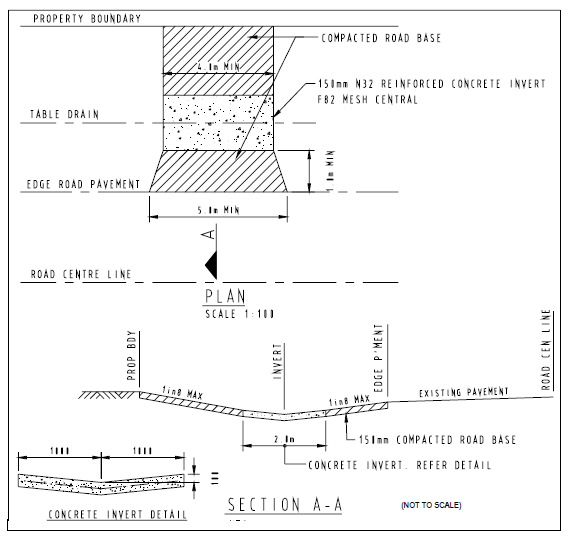
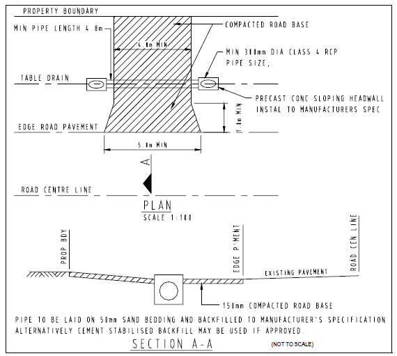
Figure 2 - Vehicle Crossover – piped
7.3.2 Non-resident workforce accommodation code
This code applies to assessing material change of use applications for non-resident workforce accommodation (NRWA) when identified in the table of assessment.
The purpose of the NRWA code is to ensure that non-resident workforce accommodation is well serviced and designed, and operated in a manner that will not detract from existing uses.
The purpose of the code will be achieved through the following overall outcomes:
- NRWA has adequate infrastructure for the use including water supply, waste water disposal, stormwater control, telecommunications and electricity;
- NRWA is appropriately located to protect the amenity of the locality, and to support the economic development of the town and Shire;
- NRWA does not detract from, or restrict the operation of, existing uses; and
- NRWA is appropriately screened and landscaped.
Table 7.3.2.1 Assessment benchmarks - Non-resident workforce accommodation
| Performance outcomes | Acceptable outcomes |
|---|---|
| PO1 The location of NRWA does not adversely affect existing industrial, residential and commercial uses, and maintains the amenity of the locality. |
AO1 All buildings are set back:
|
| PO2 The location of the NRWA is located the proximate distance to Charleville and the major road network that:
|
AO2 No acceptable outcome provided. |
| PO3 The layout of NRWA buildings does not substantially detract from the character of the area through overdevelopment of the site. |
AO3 Buildings and ancillary facilities occupy no more than 25% of the site area. |
| PO4 Development is connected to infrastructure required for the use including; water supply, waste water disposal, stormwater control, telecommunications and electricity. (Where MSC infrastructure is available, this is required in lieu of on-site infrastructure.) |
AO4 No Acceptable outcome proposed |
| PO5 NRWA buildings and waste disposal areas are screened and landscaped from site boundaries. |
AO5 No Acceptable Outcome proposed. |
| PO6 NRWA developments are temporary in nature. |
AO6.1 AO6.2 |
7.4 Other development codes
7.4.1 Operational works code
This code applies to assessing operational works applications when identified in the tables of assessment.
The purpose of the code will be achieved through the following overall outcomes:
- Operational works involving excavating and filling land:
- Site disturbance is minimised;
- Water and sediment runoff is controlled; and
- Once work is complete, the site is rehabilitated to a safe stable area that does not cause further erosion and safety issues.
- Levees are constructed in accordance with the applicable State Code;
- Development:
- Is located to avoid significant adverse impacts on matters of state environmental significance;
- Facilitates the protection and enhancement of matters of state environmental significance; and
- Protects and enhances ecological connectivity.
Table 7.4.1.1 Assessment benchmarks - Operational works
| Performance outcomes | Acceptable outcomes |
|---|---|
| Site Layout | |
|
PO1
Changes to adjoining land and natural features, including surface and groundwater are minimised and do not adversely impact adjoining properties or the locality. |
AO1 Excavation or filling on all land (except dams on rural zoned land for rural purposes):-
|
| PO2 Operational works or the construction activities for the development avoid or minimise adverse impacts on stormwater quality. |
AO2 No acceptable outcome provided. Note: Implementation of an erosion and sediment control plan (ESCP) prepared by a suitably qualified person which demonstrates that release of sediment-laden stormwater is avoided for the nominated design storm, and minimised when the nominated design storm is exceeded, by addressing design objectives listed below in Table A (construction phase) or local equivalent, for:
|
| Levees | |
| PO3 The levee does not result in—
|
AO3 Note: A hydraulic report from an RPEQ will be required to determine the hydraulic characteristics of water flow and its impacts. |
|
PO4 Any off-property impact from the levee is minimised and acceptable having regard to the following—
|
AO4 No acceptable outcome provided. Note: A hydraulic report from an RPEQ will be required to determine the hydraulic characteristics of water flow and its impacts. |
| PO5 The levee is a safe and stable structure. |
AO5 The design, construction, operation and maintenance for the levee is appropriate for the materials used and the levee’s intended function. |
|
PO6 Editors note: (For further details on levees including classification, planning and development see DNRM Guideline: Regulation of levee banks https://www.dnrm.qld.gov.au/water/catchments-planning/levees |
AO6.1 AO6.2 |
| Site rehabilitation | |
| PO7 Extractive industry provides for the progressive rehabilitation of all areas subject to extractive industry operations to a stable and restored state so the land is suitable for use by alternative land uses. |
AO7 Extractive industry provides for all rehabilitation works to be undertaken on a progressive basis in accordance with an expected final landform design and site rehabilitation plan. |
| Vegetation clearing | |
|
PO8
Development:
|
AO8 No Acceptable Outcomes provided |
Table 7.4.1.2 Construction phase—stormwater management design objectives
| Issue | Design objectives | |
|---|---|---|
| Drainage control | Temporary drainage works |
|
| Erosion control | Erosion control measures |
|
| Sediment control | Sediment control measures Design storm for sediment control basins Sediment basin dewatering |
|
| Water quality | Litter and other waste, hydrocarbons and other contaminants |
|
7.4.2 Reconfiguring a lot code
This code applies to assessing reconfiguring a lot applications when identified in the tables of assessment.
The purpose of the reconfiguring a lot code is to:
- Facilitate the creation of lots to a size and dimension of that allows the zones and precincts to achieve the intended use.
- Reconfiguring lots ensures that future lots are resilient from the impacts of flood and bushfire.
- Reconfiguring lots does not adversely impact on the cultural heritage or biodiversity values of an area or water quality.
- Reconfiguring lots does not adversely impact on the Shire’s economy.
The purpose of the code will be achieved through the following overall outcomes:
- Reconfiguration of lots creates safe, functional and suitable lots that are consistent with the existing zone and precinct intent.
- Reconfiguration of lots ensures that development can provide adequate access and services for all new lots.
- Reconfiguration of lots does not lead to a loss of biodiversity and ecological connectivity.
- Reconfiguration ensures the environmental values and quality of Queensland waters are protected and enhanced.
7.4.2.1 Assessment benchmarks – reconfiguring a lot
| Performance outcomes | Acceptable outcomes |
|---|---|
| PO1 The land is physically suitable for the anticipated future land use in terms flooding hazard, bushfire hazard and practical access. |
AO1.1 AO1.2 |
| PO2 The proposed lots have a legal point of access from local or state controlled road networks. |
AO2 No Acceptable Outcome proposed. |
|
PO3
The proposed lots are of a size and dimension to meet the outcomes for development in the zones and precincts in respect of:
|
AO3 Allotments dimensions comply with Table 7.4.2.2 |
| PO4 The development is planned, designed, constructed and managed to avoid:
|
AO4
No Acceptable Outcome proposed.
Note: A site stormwater quality management plan (SQMP) is prepared and implemented , and which:
Editor’s note: Local area stormwater management planning may include Catchment or waterway management plans, Healthy Waters Management Plans or Natural Resource Management Plans.
|
| PO5 The impacts of development on matters of state environmental significance (identified in SPP mapping – Environmental and Heritage – Biodiversity) are avoided or if avoidance is not possible, minimised |
AO5 No Acceptable Outcome proposed. |
| PO6 The proposed lots will not lead to diminished productivity of rural land, or compromise the long term viability of rural activities on the land. |
AO6 No Acceptable Outcome proposed. |
| PO7 A potable water supply and adequate sewerage services are available to each lot in a development that will be used for residential, commercial or industrial purposes. |
AO7.1 All lots within the Township zone, where reticulated water and sewerage is available, are connected to the reticulated water and sewerage service. AO7.2 All lots within the Rural and Rural Residential Zone have a potable water supply and on site sewerage. |
| Flood | |
|
PO8 Safe egress is provided to all building areas within lots in emergencies in all floods. |
AO8
Reconfiguration on land identified as flood hazard on the flood hazard maps is sited and designed so that:
|
| Bushfire | |
|
PO9 Editor’s note: “Urban purposes” and “urban area” are defined in the Planning Regulation 2017. Reconfiguration will be taken to be for rural residential purposes where proposed lots are between 2000m2 and 2ha in area. “Smaller scale” rural residential purposes will be taken to be where the average proposed lot size is 6000m2 or less. PO9.1 |
AO9.1 No new lots are created within the bushfire hazard area (Editor’s note: bushfire prone area as shown in SPP mapping – Hazards and Safety, Natural hazards, , Risk and Resilience. OR AO9.2 Lots are separated from hazardous vegetation by a distance that:
|
|
PO10 The access is available for both firefighting and maintenance/defensive works. |
AO10.1 Lot boundaries are separated from hazardous vegetation by a public road which:
Fire hydrants are designed and installed in accordance with AS2419.1 2005, unless otherwise specified by the relevant water entity. Editor’s note: Applicants should have regard to the relevant standards set out in the reconfiguration of a lot code and works codes in this planning scheme. |
|
PO11 The access is available for both firefighting and maintenance/hazard reduction works. |
AO11 Lot boundaries are separated from hazardous vegetation by a public road or fire trail which has:
|
|
PO12 However, a fire trail will not be required where it would not serve a practical fire management purpose. |
AO12 Lot boundaries are separated from hazardous vegetation by a public road or fire trail which has:
|
| PO13 The development design responds to the potential threat of bushfire and establishes clear evacuation routes which demonstrate an acceptable or tolerable risk to people. |
AO13 The lot layout:
In order to demonstrate compliance with the performance outcome, a bushfire management plan prepared by a suitably qualified person may be required. The bushfire management plan should be developed in accordance with the Public Safety Business Agency (PSBA) guideline entitled “Undertaking a Bushfire Protection Plan Advice from the Queensland Fire and Emergency Services should be sought as appropriate. |
| PO14 Critical infrastructure does not increase the potential bushfire hazard. |
AO14 Critical or potentially hazardous infrastructure such as water supply, electricity, gas and telecommunications are undergrounded. |
| Local heritage placs | |
| PO15 Development maintains an intact context and setting that is compatible with the cultural heritage significance of the place. |
AO15 No acceptable outcome is provided. |
| Stock Route Network | |
| PO16 The stock route network identified in SPP mapping – Environment and Heritage, Agriculture, Stock route network is protected from incompatible development on adjoining sites. |
AO16 No new allotments are created within or adjacent to the stock route network. |
| PO17 The integrity of pipelines carrying petroleum is maintained |
AO17 No development is located closer than 200m from a pipeline or pipeline easement identified on Schedule 2 - Strategic Map. |
Table 7.4.2.2 – acceptable outcomes for lot sizes and frontages
| Zone/Precinct | Allotment Size | Road Frontage |
|---|---|---|
| Rural Zone | 5000ha | N/A |
| Rural Residential Zone | 2ha | 70 metres |
| Recreation and Open Space Zone | N/A | N/A |
| Township Zone (excluding the Charleville precincts) | 1000m2 | 20 metres |
| Charleville commercial precinct | 400m2 | 15 metres |
| Industrial precinct | 2000m2 | 30 metres |
| Charleville residential precinct | 800m2 | 20 metres |
| Back to Top |